|
Analysis of Color Infrared
Aerial Photographs to Detect Failing Septic Systems
The methodology for utilizing CIR aerial photographs
to identify failing septic systems specifically relies on the experience and
abilities of qualified aerial photographic interpreters. ERI is a firm that
specializes in the acquisition and stereoscopic analysis of current and historical
aerial photographs for a broad range of environmental applications. ERI successfully
demonstrated, through past performance, the ability to achieve the following project
objectives:
- Identify failing systems at the property parcel level
- Establish credible survey results through ground verification processes
- Generate County compatible GIS data layers of the survey results
- Conduct spatial analysis of survey results and generate priority listings of properties
Color Infrared Aerial Photographs and Failing Septic Systems
The concept of utilizing CIR aerial photographs to
identify septic system failures dates back to 1978 when EPA's Environmental
Photographic Interpretation Center (EPIC) developed the application. The
results from these analyses performed by EPIC were used to obtain Federal
Construction Grants for wastewater treatment plants based on failure percentages.
In addition, EPA's Water Engineering Research Laboratory published a literature
review which further evaluated this methodology effectiveness in 1985. With the
advent of TMDLs for fecal coliform and the growing number of septic systems,
The value of CIR aerial photographs in the identification of individual septic
system failures is unparalleled.
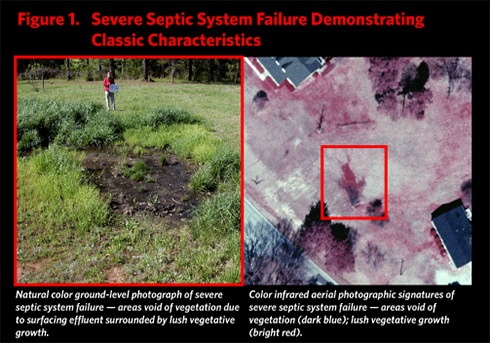
Failing septic systems exhibit distinct aerial photographic
signatures (characteristics) on CIR aerial photographs taken at the appropriate time
of the year. These signatures are caused by surfacing septic effluent and nutrients
that promote enhanced vegetation growth. In addition, the most severe septic system
failures exhibit signatures which represent dead vegetation, bare ground, and surface
effluent, each of which are readily identifiable on the CIR aerial photographs by a trained
analyst. See Figure 1.
CIR aerial photography provides several significant advantages over
the more traditional methods historically used in the identification of failing septic
systems.
With the advent of TMDL's for fecal coliform, combined with the
fact that 25% of homes in the United States utilize septic systems, and that annual failure
rates within these systems by some reports may reach 10% or higher annually (EPA, 2006),
a survey methodology which offers an accurate and cost-effective solution
to the identification of these failures can be routinely utilized to assist in the identification
and reduction of sources of fecal coliform.
To read the full article click on the following link: http://www.stormh2o.com/sw_0607_fecal.html
|